Dominik Bertram
Dominik Bertram
Research fellow in the Working Group „Regional Development“ of Prof. Dr. Tobias Chilla.
Newsroom: www.regionalentwicklung.bayern
ResearchGate: Dominik Bertram
Research
Research focus on cross-border spatial development and sustainable regional development. Quantitative and qualitative analyses, in particular visualization.
PhD Project:
Centrality beyond size: accessibility and functionality in territories with geographical specificities
The concept of centrality strives for an efficient and equitable spatial organisation of services, which is a particular challenge in territories with geographical specificities like mountain or border regions. In addition to morphological challenges in mountainous areas as well as governance issues in border regions, it is mostly a low population density that affects centrality in a particular manner.
From a methodological perspective, a settlement is usually considered to have an overarching importance or functionality if it has a high number of inhabitants. With regard to centrality as the main argument of spatially balanced distribution of services of general interest, this concept has its limitations in regions with territorial specific obstacles. In these areas, settlements can theoretically have a high surplus of importance for smaller towns, even if they do not have a high number of inhabitants. This is particularly obvious in mountainous regions. The classical concept of centrality organizes services in a way that assumes equal accessibility of all centers. However, the morphological structure of mountain regions requires a particular form of organization: a more restricted accessibility leads either to longer distances and travel times or (in the better case) to a higher level of services in smaller settlements. A similar situation is to be expected in border regions where topographical obstacles and cross-border multi-level governance systems on national borders affect centrality. From a planning perspective, centrality is practiced ‚inwardly‘ and the metropolitan areas are usually located at a certain distance to the border. Therefore, border regions are often rural areas and in terms of accessibility small towns could have a particular catchment area across the border.
For this reason, the phd project examines the role of accessibility for centrality in areas with geographical specificities. The focus is on two research strands. From a theoretical-conceptual perspective this research aims to respond to these questions: What is the interrelation between the functionality and accessibility of towns in territories with geographical specificities? What are the implications for the centrality of these towns? From a methodological perspective my research reflects on the following key question: What is the role of the indicators ‘accessibility’ and ‘number of inhabitants’ in determining centrality of towns in territories with geographical specificities?
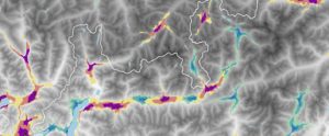
Methodologically, the analysis is based on definitions of settlement systems for selected territories with geographical specificities in terms of population size and accessibility. As case regions, so far, the Alpine region (see Fig.1) and all nine German border regions are selected. A third territory with geographical specificities will be selected in the further research process. Calculations of accessibility are applied to generate the so called ‘catchment areas’ by different means of transport within certain selected travel times. The combination of population data and accessibility catchment area is applied to define towns with centrality and an overall settlement system for the selected territory.

Fig. 1: snapshot of GIS based working material
This contribution allows to systematically measure and quantify the link between accessibility and centrality in territories with geographical specificities. It is an important input for the debate on how to organise an efficient and sustainable settlement system in geographical specific territories like mountainous regions, border regions or e.g. coastal regions.
Projects
Publications
Bertram, D.; Chilla, T.; Wilhelm, C. (2021): Short Value Chains in Food Production: The Role of Spatial Proximity for Economic and Land Use Dynamics. Land 10 (979). Online: https://doi.org/10.3390/land10090979
Bertram, D. (2020): Grenzüberschreitende Landesplanung – Funktionale Verflechtung und Raumplanung in Grenzregionen. Online unter: [doi] 10.13140/RG.2.2.24473.03689.
Bertram, D. et al. (2019): Räumliche Integration: Das Beispiel der bayerischen Grenzregionen zu Österreich und Tschechien. Working Paper No. 3 der AG Regionalentwicklung an der FAU. Online unter: https://www.geographie.nat.fau.de/files/2017/12/Lefo_19_Raeumliche-Integration-Bayern.pdf.
Curriculum Vitae
since 2020: Research fellow on the Institute of Geography
2019-2020: Research consultant for Regional Development and personal assistant of a Member of the Bavarian Parliament
2017-2019: Participation in the Working Group „Regional Development“ of Prof. Dr. Tobias Chilla
2018-2020: Master studies in Cultural Geography (Friedrich-Alexander-University Erlangen-Nuremberg), Master thesis on “Cross-border Regional Planning – Functional Integration and Spatial Planning in Border Regions”
2017-2018: Internship at Markt und Standort Beratungsgesellschaft in Erlangen
2016: Studies abroad at Universitetet i Bergen (Norway)
2014-2018: Bachelor studies in Cultural Geography (Friedrich-Alexander-University Erlangen-Nuremberg)

